


KDLF - Laughlin Afb
Located in Del Rio, United States
ICAO - DLF, IATA - DLF
Data provided by AirmateGeneral information
Coordinates: N29°21'34" W100°46'41"
Elevation is 1081 feet MSL.
Magnetic variation is 07° East View others Airports in Texas
Operational data
Special qualification required
Current time UTC:
Current local time:
Weather
METAR: KDLF 091855Z AUTO 36007KT 10SM FEW120 SCT150 BKN190 BKN220 38/16 A2966 RMK AO2 SLP028 T03800163 $
TAF: TAF KDLF 091800Z 0918/1024 31010G15KT 9999 FEW250 QNH2960INS BECMG 0923/0924 VRB06KT 9999 FEW250 QNH2960INS BECMG 1010/1011 08009KT 9000 -DZ BKN020 QNH2975INS TEMPO 1012/1015 BKN014 BECMG 1015/1016 08010G18KT 9000 -SHRA BKN030 QNH2983INS TEMPO 1017/1022 VCTS BKN040CB TX41/0922Z TN26/1012Z
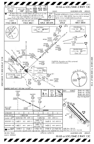
Communications frequencies: [VIEW]
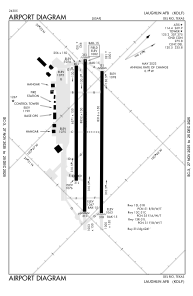
Runways:
| RWY identifier | QFU | Length (ft) | Width (ft) | Surface | LDA (ft) |
| 13C | 0° | 8852 | 150 | OTHER | |
| 31C | 0° | 8852 | 150 | OTHER | |
| 13L | 0° | 8316 | 150 | OTHER | |
| 31R | 0° | 8316 | 150 | OTHER | |
| 13R | 0° | 6571 | 150 | ASPH | |
| 31L | 0° | 6571 | 150 | ASPH |
Airport contact information
Address: Del Rio United States