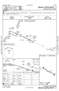
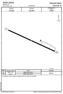


KDEH - Decorah Muni
Located in Decorah, United States
ICAO - DEH, IATA - DEH
Data provided by AirmateGeneral information
Coordinates: N43°16'32" W91°44'22"
Elevation is 1157 feet MSL.
Magnetic variation is 01° East View others Airports in Iowa
Operational data
Special qualification required
Current time UTC:
Current local time:
Weather
METAR: KDEH 090955Z AUTO 09014KT 10SM FEW043 SCT048 OVC060 13/13 A2968 RMK AO2 P0002
Communications frequencies: [VIEW]
Runways:
| RWY identifier | QFU | Length (ft) | Width (ft) | Surface | LDA (ft) |
| 11 | 115° | 4001 | 75 | CONC | |
| 29 | 295° | 4001 | 75 | CONC |
Airport contact information
Address: Decorah United States
