


KDAY - James M Cox Dayton Intl
Located in Dayton, United States
ICAO - DAY, IATA - DAY
Data provided by AirmateGeneral information
Coordinates: N39°54'8" W84°13'10"
Elevation is 1009 feet MSL.
Magnetic variation is -06° East View others Airports in Ohio
Operational data
Special qualification required
Current time UTC:
Current local time:
Weather
METAR: KDAY 082356Z 21005KT 10SM BKN170 OVC250 24/11 A2972 RMK AO2 SLP058 T02390106 10278 20239 55011
TAF: KDAY 082343Z 0900/0924 VRB03KT P6SM BKN050 OVC150 FM090400 10008KT P6SM -SHRA VCTS SCT025CB OVC050 FM090800 07008KT 5SM BR OVC025 FM091300 05009KT P6SM BKN012 FM091600 05012KT P6SM VCSH BKN015 FM091900 04012KT P6SM -SHRA VCTS BKN015CB FM092200 04011KT P6SM VCSH BKN015
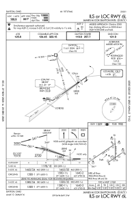
Communications frequencies: [VIEW]
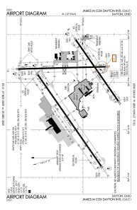
Runways:
| RWY identifier | QFU | Length (ft) | Width (ft) | Surface | LDA (ft) |
| 06L | 55° | 10901 | 150 | OTHER | 10900 |
| 24R | 235° | 10901 | 150 | OTHER | 10900 |
| 06R | 55° | 7285 | 150 | CONC | 7001 |
| 24L | 235° | 7285 | 150 | CONC | 7001 |
| 18 | 179° | 8502 | 150 | ASPH | 8502 |
| 36 | 359° | 8502 | 150 | ASPH | 8502 |
Airport contact information
Address: Dayton United States
