


KCWI - Clinton Muni
Located in Clinton, United States
ICAO - CWI, IATA - CWI
Data provided by AirmateGeneral information
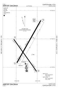
Coordinates: N41°49'51" W90°19'44"
Elevation is 707 feet MSL.
Magnetic variation is 00° East View others Airports in Iowa
Operational data
Special qualification required
Current time UTC:
Current local time:
Weather
METAR: KCWI 090756Z AUTO 05019G25KT 10SM -RA BKN050 OVC060 13/12 A2968 RMK AO2 WSHFT 0710 LTG DSNT NE AND E TSE42 SLP050 P0016 T01280117
Communications frequencies: [VIEW]
Runways:
| RWY identifier | QFU | Length (ft) | Width (ft) | Surface | LDA (ft) |
| 03 | 30° | 5204 | 100 | CONC | 5204 |
| 21 | 210° | 5204 | 100 | CONC | 5204 |
| 14 | 144° | 4201 | 75 | CONC | 4200 |
| 32 | 325° | 4201 | 75 | CONC | 4200 |
Airport contact information
Address: Clinton United States