


KCVS - Cannon Afb
Located in Clovis, United States
ICAO - CVS, IATA - CVS
Data provided by AirmateGeneral information
Coordinates: N34°22'58" W103°19'20"
Elevation is 4295 feet MSL.
Magnetic variation is 07° East View others Airports in New Mexico
Operational data
Special qualification required
Current time UTC:
Current local time:
Weather
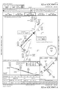
METAR: KCVS 080556Z 27007KT 10SM CLR 15/M13 A2966 RMK AO2A SLP988 T01461126 10288 20142 FZRANO $
TAF: TAF KCVS 080200Z 0802/0908 24010G15KT 9999 SKC QNH2961INS BECMG 0804/0805 VRB06KT 9999 FEW150 QNH2966INS BECMG 0815/0816 26015G25KT 9999 SKC QNH2975INS BECMG 0817/0818 28020G30KT 9999 SKC 520004 QNH2973INS BECMG 0823/0824 30012G22KT 9999 FEW100 SCT120 QNH2966INS BECMG 0901/0902 VRB06KT 9999 SCT100 QNH2968INS TX28/0822Z TN12/0812Z
Communications frequencies: [VIEW]
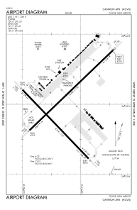
Runways:
| RWY identifier | QFU | Length (ft) | Width (ft) | Surface | LDA (ft) |
| 04 | 45° | 10003 | 150 | CONC | |
| 22 | 225° | 10003 | 150 | CONC | |
| 13 | 135° | 8196 | 150 | OTHER | |
| 31 | 315° | 8196 | 150 | OTHER |
Airport contact information
Address: Clovis United States