


KCSB - Cambridge Muni
Located in Cambridge, United States
ICAO - CSB, IATA -
Data provided by AirmateGeneral information
Coordinates: N40°18'24" W100°9'43"
Elevation is 2414 feet MSL.
Magnetic variation is 05° East View others Airports in Nebraska
Operational data
Special qualification required
Current time UTC:
Current local time:
Weather at : KMCK - Mc Cook Ben Nelson Rgnl ( 38 km )
METAR: KMCK 082253Z AUTO 30015KT 10SM BKN110 21/M03 A2972 RMK AO2 SLP051 T02111028
TAF: KMCK 081720Z 0818/0918 34016G24KT P6SM SKC FM082000 29013G21KT P6SM FEW250 FM082100 30013KT P6SM FEW250 FM091400 34010KT P6SM FEW250
Communications frequencies: [VIEW]
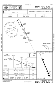
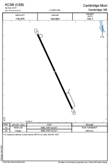
Runways:
| RWY identifier | QFU | Length (ft) | Width (ft) | Surface | LDA (ft) |
| 15 | 155° | 4098 | 60 | CONC | |
| 33 | 335° | 4098 | 60 | CONC |
Airport contact information
Address: Cambridge United States
