
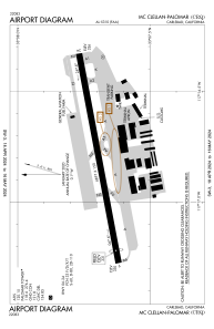


KCRQ - Mc Clellan-Palomar
Located in Carlsbad, United States
ICAO - CRQ, IATA - CLD
Data provided by AirmateGeneral information
Coordinates: N33°7'42" W117°16'48"
Elevation is 330 feet MSL.
Magnetic variation is 14° East View others Airports in California
Operational data
Special qualification required
Current time UTC:
Current local time:
Weather
METAR: KCRQ 091853Z AUTO 25006KT 10SM OVC022 18/12 A2994 RMK AO2 SLP135 T01780117
TAF: KCRQ 091734Z 0918/1018 VRB04KT P6SM BKN021 FM091900 24009KT P6SM SCT022 FM100230 VRB04KT P6SM OVC018 FM100800 VRB04KT 4SM BR OVC009 FM101600 VRB04KT 6SM BR BKN012
Communications frequencies: [VIEW]
Runways:
| RWY identifier | QFU | Length (ft) | Width (ft) | Surface | LDA (ft) |
| 06 | 79° | 4897 | 150 | ASPH | 4600 |
| 24 | 259° | 4897 | 150 | ASPH | 4897 |
| H1 | 0° | 0 | 0 | UNK |
Airport contact information
Address: Carlsbad United States

