


KCRP - Corpus Christi Intl
Located in Corpus Christi, United States
ICAO - CRP, IATA - CRP
Data provided by AirmateGeneral information
Coordinates: N27°46'20" W97°30'9"
Elevation is 46 feet MSL.
Magnetic variation is 04° East View others Airports in Texas
Operational data
Special qualification required
Current time UTC:
Current local time:
Weather
METAR: KCRP 091251Z 14008KT 4SM R13/2600VP6000FT BR FEW010 OVC016 27/26 A2964 RMK AO2 SLP036 T02720256
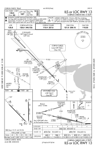
Communications frequencies: [VIEW]
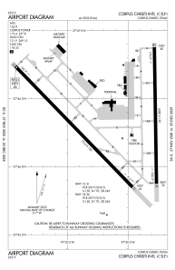
Runways:
| RWY identifier | QFU | Length (ft) | Width (ft) | Surface | LDA (ft) |
| 13 | 136° | 7510 | 150 | ASPH | 7510 |
| 31 | 316° | 7510 | 150 | ASPH | 7510 |
| 18 | 179° | 6080 | 150 | ASPH | 6080 |
| 36 | 359° | 6080 | 150 | ASPH | 6080 |
Airport contact information
Address: Corpus Christi United States