


KCPS - St Louis Downtown
Located in Cahokia/St Louis, United States
ICAO - CPS, IATA - CPS
Data provided by AirmateGeneral information
Coordinates: N38°34'13" W90°9'18"
Elevation is 412 feet MSL.
Magnetic variation is 00° East View others Airports in Illinois
Operational data
Special qualification required
Current time UTC:
Current local time:
Weather
METAR: KCPS 091553Z 28012G21KT 250V320 10SM CLR 24/14 A2971 RMK AO2 SLP058 T02390144 PNO
TAF: KCPS 091303Z 0913/1012 27007KT P6SM SCT009 TEMPO 0913/0914 BKN015 FM091800 29016G25KT P6SM FEW240 FM100100 32010KT P6SM SCT120 FM100400 34008KT P6SM BKN025 FM101000 32007KT P6SM BKN015
Communications frequencies: [VIEW]
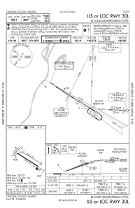
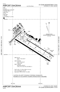
Runways:
| RWY identifier | QFU | Length (ft) | Width (ft) | Surface | LDA (ft) |
| 05 | 47° | 2799 | 75 | ASPH | 2799 |
| 23 | 227° | 2799 | 75 | ASPH | 2799 |
| 12L | 122° | 5301 | 75 | CONC | 5300 |
| 30R | 302° | 5301 | 75 | CONC | 5300 |
| 12R | 122° | 7002 | 150 | ASPH | 7002 |
| 30L | 302° | 7002 | 150 | ASPH | 7002 |
Airport contact information
Address: Cahokia/St Louis United States

