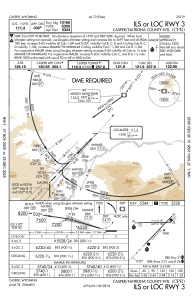
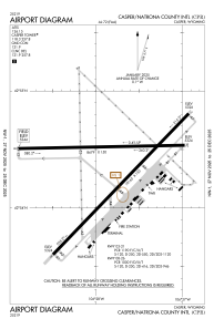


KCPR - Casper/Natrona County Intl
Located in Casper, United States
ICAO - CPR, IATA - CPR
Data provided by AirmateGeneral information
Coordinates: N42°54'21" W106°27'49"
Elevation is 5344 feet MSL.
Magnetic variation is 12° East View others Airports in Wyoming
Operational data
Special qualification required
Current time UTC:
Current local time:
Weather
METAR: KCPR 090600Z AUTO 34010KT 5SM -RA BR SCT009 OVC018 03/02 A3004 RMK AO2 P0001 T00280017
TAF: KCPR 090521Z 0906/1006 02011KT 6SM -RA BR SCT007 OVC025 TEMPO 0911/0915 2SM -SNRA SCT004 OVC007 FM091900 03013G21KT P6SM -RA SCT014 OVC023 FM100100 03009KT P6SM SCT023 BKN035
Communications frequencies: [VIEW]
Runways:
| RWY identifier | QFU | Length (ft) | Width (ft) | Surface | LDA (ft) |
| 03 | 44° | 10165 | 150 | ASPH | 10165 |
| 21 | 224° | 10165 | 150 | ASPH | 10165 |
| 08 | 89° | 8679 | 150 | ASPH | 8679 |
| 26 | 269° | 8679 | 150 | ASPH | 8679 |
Airport contact information
Address: Casper United States
Other aviation service providers
Flight schools

Crosswind Aviation Management, Llc
Crosswind Aviation Management, Llc
mike@crosswindavi.com+1(307)472-4359