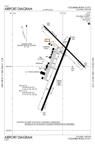


KCOU - Columbia Rgnl
Located in Columbia, United States
ICAO - COU, IATA - COU
Data provided by AirmateGeneral information
Coordinates: N38°49'4" W92°13'4"
Elevation is 889 feet MSL.
Magnetic variation is 00° East View others Airports in Missouri
Operational data
Special qualification required
Current time UTC:
Current local time:
Weather
METAR: KCOU 091754Z 31013G21KT 10SM SCT045 22/12 A2984 RMK AO2 SLP098 T02220117 10222 20139 51016
TAF: KCOU 091730Z 0918/1018 30015G24KT P6SM SCT035 FM100000 33008KT P6SM BKN035 FM100300 33008KT P6SM BKN021 FM100500 34007KT P6SM BKN018 FM101400 35007KT P6SM BKN020
Communications frequencies: [VIEW]
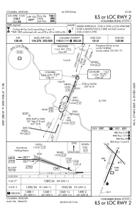
Runways:
| RWY identifier | QFU | Length (ft) | Width (ft) | Surface | LDA (ft) |
| 02 | 21° | 7401 | 150 | CONC | |
| 20 | 201° | 7401 | 150 | CONC | |
| 13 | 135° | 5500 | 100 | CONC | 5500 |
| 31 | 315° | 5500 | 100 | CONC | 5500 |
Airport contact information
Address: Columbia United States
