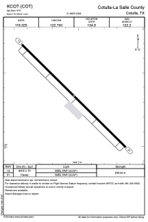


KCOT - Cotulla-La Salle County
Located in Cotulla, United States
ICAO - COT, IATA - COT
Data provided by AirmateGeneral information
Coordinates: N28°27'21" W99°13'2"
Elevation is 474 feet MSL.
Magnetic variation is 06° East View others Airports in Texas
Operational data
Special qualification required
Current time UTC:
Current local time:
Weather
TAF: KCOT 091130Z 0912/1012 14006KT 4SM BR OVC008 FM091400 11005KT 5SM BR OVC015 FM091600 VRB06KT 6SM HZ SCT015 BKN250 FM100800 09010KT P6SM OVC015
Communications frequencies: [VIEW]
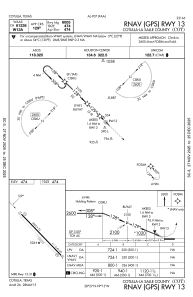
Runways:
| RWY identifier | QFU | Length (ft) | Width (ft) | Surface | LDA (ft) |
| 13 | 134° | 6005 | 75 | ASPH | |
| 31 | 314° | 6005 | 75 | ASPH |
Airport contact information
Address: Cotulla United States