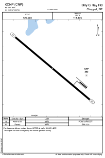


KCNP - Billy G Ray Fld
Located in Chappell, United States
ICAO - CNP, IATA -
Data provided by AirmateGeneral information
Coordinates: N41°4'39" W102°27'51"
Elevation is 3681 feet MSL.
Magnetic variation is 10° East View others Airports in Nebraska
Operational data
Special qualification required
Current time UTC:
Current local time:
Weather at : KSNY - Sidney Muni/Lloyd W Carr Fld ( 44 km )
METAR: KSNY 082253Z AUTO 33015G22KT 10SM BKN070 OVC090 13/M04 A2977 RMK AO2 PK WND 29030/2220 SLP071 T01331044
TAF: KSNY 082320Z 0900/0924 32015KT P6SM OVC070 FM091000 34009KT P6SM OVC028 FM091200 34010KT P6SM VCSH OVC020 FM091300 34010KT P6SM VCSH OVC006 FM091700 35010G20KT P6SM VCSH OVC025 FM092100 36012KT P6SM OVC040
Communications frequencies: [VIEW]
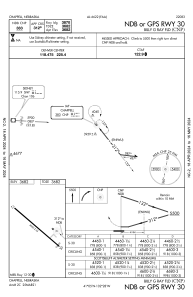
Runways:
| RWY identifier | QFU | Length (ft) | Width (ft) | Surface | LDA (ft) |
| 12 | 130° | 4000 | 55 | ASPH | |
| 30 | 310° | 4000 | 55 | ASPH |
Airport contact information
Address: Chappell United States