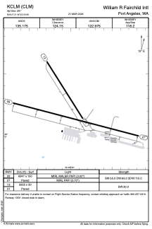


KCLM - William R Fairchild Intl
Located in Port Angeles, United States
ICAO - CLM, IATA - CLM
Data provided by AirmateGeneral information
Coordinates: N48°7'13" W123°29'59"
Elevation is 291 feet MSL.
Magnetic variation is 16° East View others Airports in Washington
Operational data
Special qualification required
Current time UTC:
Current local time:
Weather
METAR: KCLM 090453Z AUTO 26004KT 10SM CLR 09/05 A3040 RMK AO2 SLP295 T00940050
TAF: KCLM 082320Z 0900/0924 31009KT P6SM SKC FM090500 25005KT P6SM SKC FM091000 VRB03KT P6SM SKC FM091500 09008KT P6SM SKC
Communications frequencies: [VIEW]
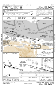
Runways:
| RWY identifier | QFU | Length (ft) | Width (ft) | Surface | LDA (ft) |
| 09 | 105° | 6347 | 150 | ASPH | |
| 27 | 285° | 6347 | 150 | ASPH | |
| 13 | 148° | 3255 | 50 | ASPH | |
| 31 | 328° | 3255 | 50 | ASPH |
Airport contact information
Address: Port Angeles United States
