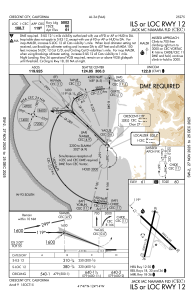
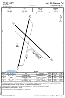


KCEC - Jack Mc Namara Fld
Located in Crescent City, United States
ICAO - CEC, IATA - CEC
Data provided by AirmateGeneral information
Coordinates: N41°46'49" W124°14'12"
Elevation is 60 feet MSL.
Magnetic variation is 14° East View others Airports in California
Operational data
Special qualification required
Current time UTC:
Current local time:
Weather
METAR: KCEC 180256Z AUTO 01010G25KT 7SM CLR 11/07 A2994 RMK AO2 PK WND 36027/0235 SLP140 T01110072 55000
TAF: KCEC 172339Z 1800/1824 34019G30KT P6SM SKC FM180400 35014G22KT 6SM HZ SKC FM181100 18005KT 5SM BR BKN005 FM181600 34008G18KT P6SM SCT007
Communications frequencies: [VIEW]
Runways:
| RWY identifier | QFU | Length (ft) | Width (ft) | Surface | LDA (ft) |
| 12 | 133° | 5002 | 150 | ASPH | 5002 |
| 30 | 313° | 5002 | 150 | ASPH | 5002 |
| 18 | 193° | 5000 | 150 | ASPH | 4850 |
| 36 | 13° | 5000 | 150 | ASPH | 4850 |
Airport contact information
Address: Crescent City United States