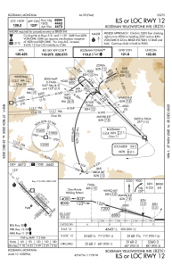
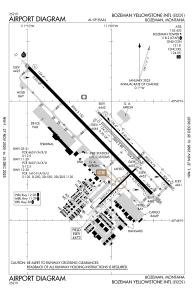


KBZN - Bozeman Yellowstone Intl
Located in Bozeman, United States
ICAO - BZN, IATA - BZN
Data provided by AirmateGeneral information
Coordinates: N45°46'38" W111°9'1"
Elevation is 4473 feet MSL.
Magnetic variation is 13° East View others Airports in Montana
Operational data
Special qualification required
Current time UTC:
Current local time:
Weather
METAR: KBZN 081456Z 29006KT 10SM OVC019 02/01 A2998 RMK AO2 UPB31E51SNE25 SLP172 P0000 60001 T00220006 53013
TAF: KBZN 081419Z 0814/0918 28011KT P6SM SCT010 BKN020 TEMPO 0814/0818 5SM -SHRA BR BKN010 FM081800 33011KT P6SM SCT012 BKN025 TEMPO 0819/0822 32015G22KT -SHRA BKN015 FM090300 VRB06KT 6SM -RA BR SCT015 BKN030
Communications frequencies: [VIEW]
Runways:
| RWY identifier | QFU | Length (ft) | Width (ft) | Surface | LDA (ft) |
| 03 | 46° | 2650 | 75 | ASPH | 2650 |
| 21 | 226° | 2650 | 75 | ASPH | 2650 |
| 11 | 136° | 5050 | 75 | ASPH | 5050 |
| 29 | 316° | 5050 | 75 | ASPH | 5050 |
| 11G | 136° | 2802 | 80 | GRASS | |
| 29G | 316° | 2802 | 80 | GRASS | |
| 12 | 136° | 8994 | 150 | ASPH | 8994 |
| 30 | 316° | 8994 | 150 | ASPH | 8994 |
Airport contact information
Address: Bozeman United States

