


KBWI - Baltimore/Washington Intl Thurgood Marshall
Located in Baltimore, United States
ICAO - BWI, IATA - BWI
Data provided by AirmateGeneral information
Coordinates: N39°10'33" W76°40'8"
Elevation is 143 feet MSL.
Magnetic variation is -11° East View others Airports in Maryland
Operational data
Special qualification required
Current time UTC:
Current local time:
Weather
TAF: KBWI 091735Z 0918/1024 05008KT P6SM FEW040 BKN090 FM092000 08009KT 6SM -SHRA OVC030 FM092200 08010KT 6SM -SHRA OVC015 FM100100 08007KT P6SM VCTS OVC025CB FM100500 08006KT P6SM -SHRA OVC008 FM101700 08009KT 4SM -SHRA BR OVC008
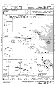
Communications frequencies: [VIEW]
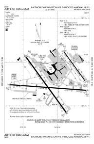
Runways:
| RWY identifier | QFU | Length (ft) | Width (ft) | Surface | LDA (ft) |
| 10 | 94° | 10503 | 150 | ASPH | 9953 |
| 28 | 274° | 10503 | 150 | ASPH | 9803 |
| 15L | 144° | 5000 | 100 | ASPH | 5000 |
| 33R | 324° | 5000 | 100 | ASPH | 5000 |
| 15R | 144° | 9501 | 150 | ASPH | 8301 |
| 33L | 324° | 9501 | 150 | ASPH | 8301 |
Airport contact information
Address: Baltimore United States