


KBST - Belfast Muni
Located in Belfast, United States
ICAO - BST, IATA -
Data provided by AirmateGeneral information
Coordinates: N44°24'34" W69°0'43"
Elevation is 197 feet MSL.
Magnetic variation is -18° East View others Airports in Maine
Operational data
Special qualification required
Current time UTC:
Current local time:
Weather at : KRKD - Knox County Rgnl ( 39 km )
METAR: KRKD 082108Z AUTO 02005KT 2SM -RA BR OVC004 08/08 A2959 RMK AO2 P0001
TAF: KRKD 081734Z 0818/0918 07008KT P6SM OVC060 FM081930 07009KT 4SM -SHRA BR OVC012 FM082200 04006KT 2SM -SHRA BR OVC002 FM091100 01010G18KT 4SM BR OVC004
Communications frequencies: [VIEW]
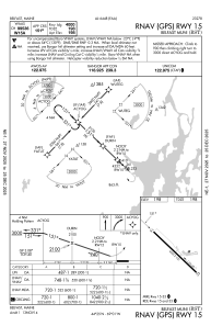
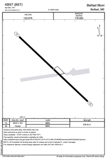
Runways:
| RWY identifier | QFU | Length (ft) | Width (ft) | Surface | LDA (ft) |
| 15 | 133° | 4000 | 100 | ASPH | |
| 33 | 313° | 4000 | 100 | ASPH |
Airport contact information
Address: Belfast United States