


KBOS - General Edward Lawrence Logan Intl
Located in Boston, United States
ICAO - BOS, IATA - BOS
Data provided by AirmateGeneral information
Coordinates: N42°21'47" W71°0'23"
Elevation is 19 feet MSL.
Magnetic variation is -15° East View others Airports in Massachusetts
Operational data
Special qualification required
Current time UTC:
Current local time:
Weather
METAR: KBOS 090954Z 30009KT 10SM FEW006 BKN047 13/11 A2964 RMK AO2 SLP036 T01330106 $
TAF: KBOS 090905Z 0909/1012 29008KT P6SM BKN040 FM091200 34010KT P6SM BKN025 FM091700 04010KT P6SM BKN050 FM092200 07010KT P6SM BKN050 FM100200 06010KT P6SM BKN025
Communications frequencies: [VIEW]
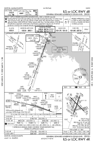
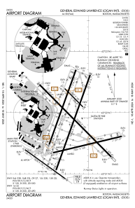
Runways:
| RWY identifier | QFU | Length (ft) | Width (ft) | Surface | LDA (ft) |
| 04L | 20° | 7864 | 150 | ASPH | 7864 |
| 22R | 200° | 7864 | 150 | ASPH | 7046 |
| 04R | 20° | 10006 | 150 | ASPH | 8851 |
| 22L | 200° | 10006 | 150 | ASPH | 8806 |
| 09 | 77° | 7001 | 150 | ASPH | 7001 |
| 27 | 257° | 7001 | 150 | ASPH | 7001 |
| 14 | 125° | 5000 | 100 | ASPH | 5000 |
| 32 | 305° | 5000 | 100 | ASPH | 5000 |
| 15L | 135° | 2557 | 100 | ASPH | 2557 |
| 33R | 315° | 2557 | 100 | ASPH | 2557 |
| 15R | 135° | 10083 | 150 | ASPH | 9202 |
| 33L | 315° | 10083 | 150 | ASPH | 10083 |
Airport contact information
Address: Boston United States