


KBMI - Central Il Rgnl/Bloomington-Normal
Located in Bloomington/Normal, United States
ICAO - BMI, IATA - BMI
Data provided by AirmateGeneral information
Coordinates: N40°28'38" W88°54'57"
Elevation is 871 feet MSL.
Magnetic variation is -03° East View others Airports in Illinois
Operational data
Special qualification required
Current time UTC:
Current local time:
Weather
METAR: KBMI 091556Z 06012KT 10SM OVC011 17/14 A2967 RMK AO2 SLP044 T01670139
TAF: KBMI 091450Z 0915/1012 04014KT P6SM BKN008 OVC015 FM091900 03012G20KT P6SM VCSH OVC015 FM100300 03010KT P6SM OVC025
Communications frequencies: [VIEW]
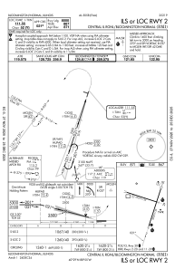
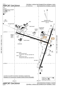
Runways:
| RWY identifier | QFU | Length (ft) | Width (ft) | Surface | LDA (ft) |
| 02 | 18° | 8000 | 150 | CONC | 8000 |
| 20 | 198° | 8000 | 150 | CONC | 8000 |
| 11 | 107° | 6525 | 150 | OTHER | 6525 |
| 29 | 287° | 6525 | 150 | OTHER | 6525 |
Airport contact information
Address: Bloomington/Normal United States
