
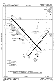


KBIS - Bismarck Muni
Located in Bismarck, United States
ICAO - BIS, IATA - BIS
Data provided by AirmateGeneral information
Coordinates: N46°46'22" W100°44'45"
Elevation is 1661 feet MSL.
Magnetic variation is 07° East View others Airports in North Dakota
Operational data
Special qualification required
Current time UTC:
Current local time:
Weather
METAR: KBIS 082052Z AUTO 13010G17KT 10SM SCT060 18/05 A2977 RMK AO2 SLP085 T01830050 51024
TAF: KBIS 081723Z 0818/0918 09009KT P6SM BKN040 FM090100 01007KT P6SM SCT110
Communications frequencies: [VIEW]
Runways:
| RWY identifier | QFU | Length (ft) | Width (ft) | Surface | LDA (ft) |
| 03 | 39° | 6600 | 100 | ASPH | 6600 |
| 21 | 219° | 6600 | 100 | ASPH | 6600 |
| 13 | 138° | 8794 | 150 | OTHER | 8794 |
| 31 | 318° | 8794 | 150 | OTHER | 8794 |
Airport contact information
Address: Bismarck United States
