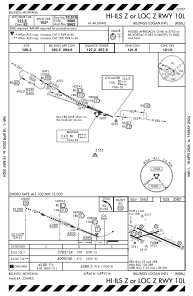
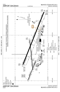


KBIL - Billings Logan Intl
Located in Billings, United States
ICAO - BIL, IATA - BIL
Data provided by AirmateGeneral information
Coordinates: N45°48'28" W108°32'37"
Elevation is 3662 feet MSL.
Magnetic variation is 10° East View others Airports in Montana
Operational data
Special qualification required
Current time UTC:
Current local time:
Weather
METAR: KBIL 082153Z 34011KT 10SM FEW014 BKN029 OVC037 10/08 A2996 RMK RAE42 SLP153 VCSH S-W SHRA DSNT NW-SE P0003 T01000083
TAF: KBIL 081732Z 0818/0918 34018G25KT P6SM -SHRA OVC018 FM090300 35015KT 6SM -SHRA SCT007 OVC012 FM090600 35011KT 6SM -SHRA BR OVC007
Communications frequencies: [VIEW]
Runways:
| RWY identifier | QFU | Length (ft) | Width (ft) | Surface | LDA (ft) |
| 07 | 84° | 5501 | 75 | ASPH | 5501 |
| 25 | 264° | 5501 | 75 | ASPH | 5501 |
| 10L | 111° | 10518 | 150 | ASPH | 10518 |
| 28R | 291° | 10518 | 150 | ASPH | 10518 |
| 10R | 111° | 3800 | 75 | ASPH | 3801 |
| 28L | 291° | 3800 | 75 | ASPH | 3801 |
Airport contact information
Address: Billings United States

