


KBHM - Birmingham-Shuttlesworth Intl
Located in Birmingham, United States
ICAO - BHM, IATA - BHM
Data provided by AirmateGeneral information
Coordinates: N33°33'50" W86°45'8"
Elevation is 650 feet MSL.
Magnetic variation is -03° East View others Airports in Alabama
Operational data
Special qualification required
Current time UTC:
Current local time:
Weather
METAR: KBHM 090553Z 20010KT 10SM BKN070 26/21 A2981 RMK AO2 SLP084 T02560206 10294 20256 403060233 50011
TAF: KBHM 090540Z 0906/1006 20012KT P6SM BKN080 FM090800 21009KT 6SM BR VCSH BKN035 FM091000 22009KT 6SM SHRA BR BKN013 TEMPO 0912/0916 4SM TSRA BR OVC008CB FM091800 22009KT P6SM BKN025 FM092000 24009KT P6SM BKN045 FM100100 VRB04KT P6SM SCT160
Communications frequencies: [VIEW]
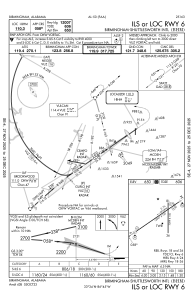
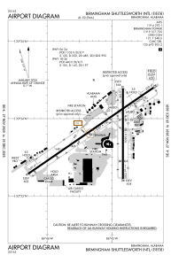
Runways:
| RWY identifier | QFU | Length (ft) | Width (ft) | Surface | LDA (ft) |
| 06 | 55° | 12007 | 150 | ASPH | 12007 |
| 24 | 235° | 12007 | 150 | ASPH | 10801 |
| 18 | 180° | 7099 | 150 | ASPH | 7099 |
| 36 | 0° | 7099 | 150 | ASPH | 7099 |
Airport contact information
Address: Birmingham United States

