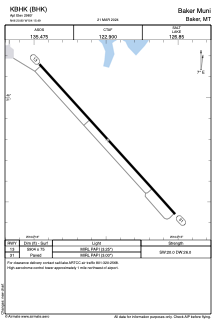


KBHK - Baker Muni
Located in Baker, United States
ICAO - BHK, IATA -
Data provided by AirmateGeneral information
Coordinates: N46°20'48" W104°15'29"
Elevation is 2980 feet MSL.
Magnetic variation is 09° East View others Airports in Montana
Operational data
Special qualification required
Current time UTC:
Current local time:
Weather
METAR: KBHK 081951Z AUTO 05014G23KT 10SM SCT027 OVC037 09/04 A2977 RMK AO2 RAE01 SLP089 P0000 T00940039
Communications frequencies: [VIEW]
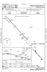
Runways:
| RWY identifier | QFU | Length (ft) | Width (ft) | Surface | LDA (ft) |
| 13 | 138° | 5904 | 75 | ASPH | |
| 31 | 318° | 5904 | 75 | ASPH |
Airport contact information
Address: Baker United States