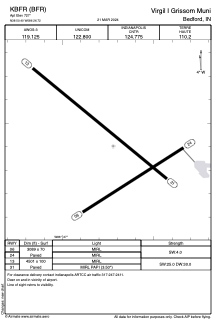


KBFR - Virgil I Grissom Muni
Located in Bedford, United States
ICAO - BFR, IATA - BFR
Data provided by AirmateGeneral information
Coordinates: N38°50'24" W86°26'43"
Elevation is 727 feet MSL.
Magnetic variation is -04° East View others Airports in Indiana
Operational data
Special qualification required
Current time UTC:
Current local time:
Weather at : KBMG - Monroe County ( 37 km )
METAR: KBMG 090853Z AUTO 13005KT 10SM OVC100 18/16 A2964 RMK AO2 SLP028 60009 T01780161 55012
TAF: KBMG 090520Z 0906/1006 12009KT P6SM VCSH OVC045 FM091100 20009KT P6SM BKN040 FM091900 26013KT P6SM -TSRA BKN025CB FM092200 29014G23KT P6SM VCTS SCT025CB BKN100 FM100000 33012KT P6SM OVC021
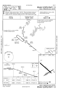
Communications frequencies: [VIEW]
Runways:
| RWY identifier | QFU | Length (ft) | Width (ft) | Surface | LDA (ft) |
| 06 | 58° | 3089 | 70 | CONC | |
| 24 | 238° | 3089 | 70 | CONC | |
| 13 | 129° | 4501 | 100 | CONC | |
| 31 | 309° | 4501 | 100 | CONC |
Airport contact information
Address: Bedford United States
