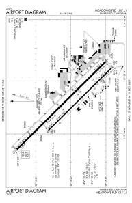


KBFL - Meadows Fld
Located in Bakersfield, United States
ICAO - BFL, IATA - BFL
Data provided by AirmateGeneral information
Coordinates: N35°26'2" W119°3'28"
Elevation is 509 feet MSL.
Magnetic variation is 14° East View others Airports in California
Operational data
Special qualification required
Current time UTC:
Current local time:
Weather
TAF: KBFL 091720Z 0918/1018 VRB05KT P6SM FEW200 FM092200 33012KT P6SM FEW200 FM100300 VRB05KT P6SM FEW200
Communications frequencies: [VIEW]
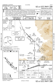
Runways:
| RWY identifier | QFU | Length (ft) | Width (ft) | Surface | LDA (ft) |
| 12L | 135° | 10849 | 150 | ASPH | 10848 |
| 30R | 315° | 10849 | 150 | ASPH | 7429 |
| 12R | 135° | 7700 | 100 | ASPH | 7703 |
| 30L | 315° | 7700 | 100 | ASPH | 6203 |
Airport contact information
Address: Bakersfield United States
Other aviation service providers
Repair station

Flight schools

Bakersfield Flying Club, Inc.
Bakersfield Flying Club, Inc.
bakersfieldflyingclub@gmail.com+1(661)619-6943