


KBED - Laurence G Hanscom Fld
Located in Bedford, United States
ICAO - BED, IATA - BED
Data provided by AirmateGeneral information
Coordinates: N42°28'12" W71°17'20"
Elevation is 132 feet MSL.
Magnetic variation is -16° East View others Airports in Massachusetts
Operational data
Special qualification required
Current time UTC:
Current local time:
Weather
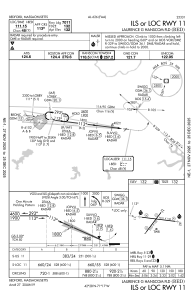
METAR: KBED 090551Z AUTO 00000KT 8SM OVC005 13/12 A2960 RMK AO2 SLP037 60000 T01280122 10128 20122 50009
TAF: KBED 090531Z 0906/1006 21003KT 2SM BR OVC003 FM090800 30003KT 2SM BR BKN003 FM091000 31005KT P6SM BKN060 FM091500 34007KT P6SM BKN030 FM092100 09009KT P6SM OVC040 FM100300 06006KT P6SM VCSH BKN015
Communications frequencies: [VIEW]
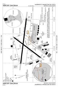
Runways:
| RWY identifier | QFU | Length (ft) | Width (ft) | Surface | LDA (ft) |
| 05 | 37° | 5107 | 150 | ASPH | 5107 |
| 23 | 217° | 5107 | 150 | ASPH | 5107 |
| 11 | 97° | 7011 | 150 | ASPH | 7011 |
| 29 | 277° | 7011 | 150 | ASPH | 7011 |
Airport contact information
Address: Bedford United States
Other aviation service providers
Repair station

Flight schools

Hanscom's Aero Club Flight Training Center
Hanscom's Aero Club Flight Training Center
heidi.breault@hanscom.af.mil+1(781)225-5849