


KBAD - Barksdale Afb
Located in Bossier City, United States
ICAO - BAD, IATA - BAD
Data provided by AirmateGeneral information
Coordinates: N32°30'7" W93°39'45"
Elevation is 165 feet MSL.
Magnetic variation is 02° East View others Airports in Louisiana
Operational data
Special qualification required
Current time UTC:
Current local time:
Weather
METAR: KBAD 091235Z AUTO 07003KT 3SM BR CLR 24/23 A2971 RMK AO2 SLP063 $
TAF: TAF AMD KBAD 091230Z 0912/1018 VRB06KT 4000 BR SCT020 QNH2972INS BECMG 0914/0915 VRB06KT 9999 NSW SCT030 QNH2976INS BECMG 0917/0918 07006KT 9999 FEW040 QNH2971INS BECMG 1001/1002 03006KT 9999 -SHRA VCTS OVC030CB QNH2972INS BECMG 1005/1006 03006KT 9999 NSW OVC025 QNH2978INS TX31/0921Z TN18/1012Z
Communications frequencies: [VIEW]
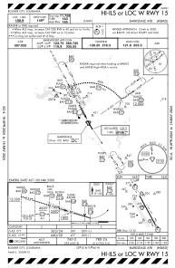
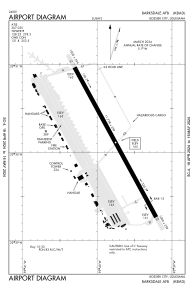
Runways:
| RWY identifier | QFU | Length (ft) | Width (ft) | Surface | LDA (ft) |
| 15 | 151° | 11758 | 299 | OTHER | |
| 33 | 331° | 11758 | 299 | OTHER |
Airport contact information
Address: Bossier City United States