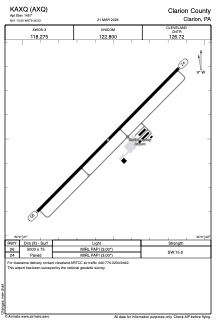


KAXQ - Clarion County
Located in Clarion, United States
ICAO - AXQ, IATA -
Data provided by AirmateGeneral information
Coordinates: N41°13'30" W79°26'32"
Elevation is 1457 feet MSL.
Magnetic variation is -10° East View others Airports in Pennsylvania
Operational data
Special qualification required
Current time UTC:
Current local time:
Weather at : KFKL - Venango Rgnl ( 39 km )
METAR: KFKL 090656Z AUTO 04005KT 10SM CLR 09/09 A2978 RMK AO2 SLP081 T00940094
TAF: KFKL 090538Z 0906/1006 04004KT P6SM BKN250 FM091500 09008KT P6SM VCSH BKN035 PROB30 0919/0923 6SM -SHRA BKN035 FM092300 04005KT 5SM -SHRA BKN030 FM100300 04006KT 4SM -SHRA BR BKN010
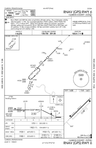
Communications frequencies: [VIEW]
Runways:
| RWY identifier | QFU | Length (ft) | Width (ft) | Surface | LDA (ft) |
| 06 | 45° | 5003 | 75 | ASPH | |
| 24 | 225° | 5003 | 75 | ASPH |
Airport contact information
Address: Clarion United States
Other aviation service providers
Flight schools

Clarion County Airport Authority
Clarion County Airport Authority
manager@clarionairport.com8142269993