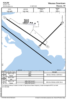


KAUW - Wausau Downtown
Located in Wausau, United States
ICAO - AUW, IATA - AUW
Data provided by AirmateGeneral information
Coordinates: N44°55'35" W89°37'37"
Elevation is 1201 feet MSL.
Magnetic variation is -03° East View others Airports in Wisconsin
Operational data
Special qualification required
Current time UTC:
Current local time:
Weather
METAR: KAUW 091054Z AUTO VRB03KT 10SM FEW029 SCT060 09/05 A2984 RMK AO2 SLP108 T00940050
TAF: KAUW 091131Z 0912/1012 05008G15KT P6SM VCSH SCT030 BKN050 FM091700 04008KT P6SM BKN050 FM100100 04004KT P6SM SCT050 FM100400 03003KT P6SM SKC
Communications frequencies: [VIEW]
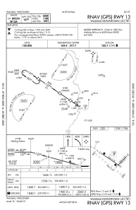
Runways:
| RWY identifier | QFU | Length (ft) | Width (ft) | Surface | LDA (ft) |
| 05 | 44° | 3041 | 100 | ASPH | |
| 23 | 224° | 3041 | 100 | ASPH | |
| 12W | 0° | 8000 | 300 | WATER | |
| 30W | 0° | 8000 | 300 | WATER | |
| 13 | 124° | 5200 | 100 | ASPH | |
| 31 | 304° | 5200 | 100 | ASPH |
Airport contact information
Address: Wausau United States
