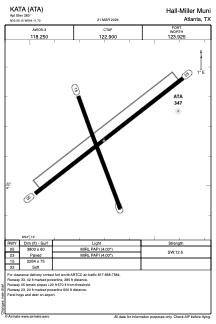


KATA - Hall-Miller Muni
Located in Atlanta, United States
ICAO - ATA, IATA -
Data provided by AirmateGeneral information
Coordinates: N33°6'9" W94°11'42"
Elevation is 280 feet MSL.
Magnetic variation is 04° East View others Airports in Texas
Operational data
Special qualification required
Current time UTC:
Current local time:
Weather at : KTXK - Texarkana Rgnl-Webb Fld ( 43 km )
METAR: KTXK 090453Z AUTO 14009KT 10SM FEW060 FEW110 23/20 A2966 RMK AO2 LTG DSNT W RAB09E50 TSB08E23 SLP038 P0002 T02330200
TAF: KTXK 082335Z 0900/0924 18009KT 3SM HZ FEW025 OVC035 FM090300 19008KT P6SM VCTS BKN040CB FM090400 VRB25G35KT 2SM +TSRA BR OVC025CB FM090700 VRB05KT P6SM SCT070 BKN090 FM091200 VRB03KT P6SM BKN020 FM091600 06006KT P6SM BKN035
Communications frequencies: [VIEW]
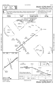
Runways:
| RWY identifier | QFU | Length (ft) | Width (ft) | Surface | LDA (ft) |
| 05 | 52° | 3800 | 60 | ASPH | |
| 23 | 232° | 3800 | 60 | ASPH | |
| 15 | 160° | 2264 | 75 | GRASS | |
| 33 | 340° | 2264 | 75 | GRASS |
Airport contact information
Address: Atlanta United States