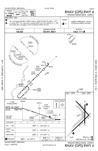
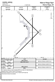


KARG - Walnut Ridge Rgnl
Located in Walnut Ridge, United States
ICAO - ARG, IATA - ARG
Data provided by AirmateGeneral information
Coordinates: N36°7'29" W90°55'30"
Elevation is 279 feet MSL.
Magnetic variation is 01° East View others Airports in Arkansas
Operational data
Special qualification required
Current time UTC:
Current local time:
Weather
METAR: KARG 172156Z AUTO 00000KT 10SM -RA SCT080 SCT090 23/21 A2976 RMK AO2 RAB02E20B47 SLP078 P0000 T02330206
Communications frequencies: [VIEW]
Runways:
| RWY identifier | QFU | Length (ft) | Width (ft) | Surface | LDA (ft) |
| 04 | 45° | 6001 | 150 | ASPH | |
| 22 | 225° | 6001 | 150 | ASPH | |
| 13 | 135° | 5003 | 150 | CONC | |
| 31 | 315° | 5003 | 150 | CONC | |
| 18 | 180° | 5001 | 150 | CONC | |
| 36 | 0° | 5001 | 150 | CONC |
Airport contact information
Address: Walnut Ridge United States