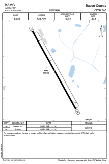


KAMG - Bacon County
Located in Alma, United States
ICAO - AMG, IATA -
Data provided by AirmateGeneral information
Coordinates: N31°32'10" W82°30'24"
Elevation is 199 feet MSL.
Magnetic variation is -06° East View others Airports in Georgia
Operational data
Special qualification required
Current time UTC:
Current local time:
Weather
METAR: KAMG 081753Z AUTO 23007G15KT 200V270 10SM BKN045 31/17 A2989 RMK AO2 SLP118 T03110172 10311 20222 56015
Communications frequencies: [VIEW]
Runways:
| RWY identifier | QFU | Length (ft) | Width (ft) | Surface | LDA (ft) |
| 16 | 151° | 5000 | 100 | ASPH | |
| 34 | 331° | 5000 | 100 | ASPH |
Airport contact information
Address: Alma United States