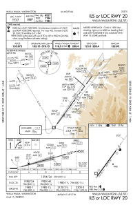
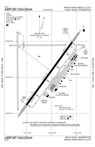


KALW - Walla Walla Rgnl
Located in Walla Walla, United States
ICAO - ALW, IATA - ALW
Data provided by AirmateGeneral information
Coordinates: N46°5'33" W118°17'3"
Elevation is 1194 feet MSL.
Magnetic variation is 14° East View others Airports in Washington
Operational data
Special qualification required
Current time UTC:
Current local time:
Weather
METAR: KALW 091053Z AUTO 11003KT 10SM CLR 06/03 A3031 RMK AO2 SLP267 T00610033
TAF: KALW 090524Z 0906/1006 10006KT P6SM BKN200 FM091500 VRB05KT P6SM FEW250 FM092100 03009KT P6SM SKC
Communications frequencies: [VIEW]
Runways:
| RWY identifier | QFU | Length (ft) | Width (ft) | Surface | LDA (ft) |
| 02 | 36° | 6527 | 150 | CONC | 6527 |
| 20 | 216° | 6527 | 150 | CONC | 6527 |
Airport contact information
Address: Walla Walla United States
