
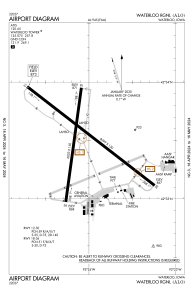


KALO - Waterloo Rgnl
Located in Waterloo, United States
ICAO - ALO, IATA - ALO
Data provided by AirmateGeneral information
Coordinates: N42°33'30" W92°24'4"
Elevation is 873 feet MSL.
Magnetic variation is 00° East View others Airports in Iowa
Operational data
Special qualification required
Current time UTC:
Current local time:
Weather
METAR: KALO 090715Z AUTO 29005KT 5SM TSRA BR FEW019 BKN031 OVC080 14/13 A2973 RMK AO2 LTG DSNT E-SW TSB07 P0005 T01440128
Communications frequencies: [VIEW]
Runways:
| RWY identifier | QFU | Length (ft) | Width (ft) | Surface | LDA (ft) |
| 12 | 128° | 8399 | 150 | ASPH | 8399 |
| 30 | 308° | 8399 | 150 | ASPH | 8399 |
| 18 | 188° | 6003 | 150 | OTHER | 6003 |
| 36 | 8° | 6003 | 150 | OTHER | 6003 |
Airport contact information
Address: Waterloo United States
