


KALB - Albany Intl
Located in Albany, United States
ICAO - ALB, IATA - ALB
Data provided by AirmateGeneral information
Coordinates: N42°44'57" W73°48'7"
Elevation is 284 feet MSL.
Magnetic variation is -13° East View others Airports in New York
Operational data
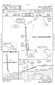
Special qualification required
Current time UTC:
Current local time:
Weather
METAR: KALB 081951Z 01005KT 10SM SCT035 BKN100 26/14 A2949 RMK AO2 SLP986 T02610139
TAF: KALB 081732Z 0818/0918 19006KT P6SM FEW012 SCT030 FM081900 27015G25KT P6SM VCSH FEW015 SCT040 FM090100 29011G18KT P6SM BKN050 FM090800 32009KT P6SM BKN025 FM091300 34006KT P6SM OVC040
Communications frequencies: [VIEW]
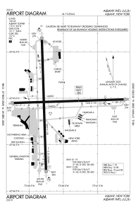
Runways:
| RWY identifier | QFU | Length (ft) | Width (ft) | Surface | LDA (ft) |
| 01 | 358° | 8500 | 150 | ASPH | 8500 |
| 19 | 178° | 8500 | 150 | ASPH | 8500 |
| 10 | 88° | 7200 | 150 | ASPH | 6780 |
| 28 | 268° | 7200 | 150 | ASPH | 6007 |
Airport contact information
Address: Albany United States
