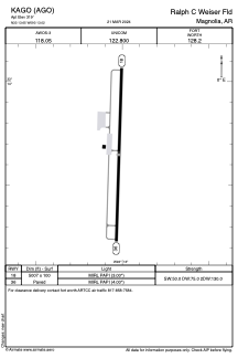


KAGO - Ralph C Weiser Fld
Located in Magnolia, United States
ICAO - AGO, IATA - AGO
Data provided by AirmateGeneral information
Coordinates: N33°13'39" W93°13'1"
Elevation is 319 feet MSL.
Magnetic variation is 01° East View others Airports in Arkansas
Operational data
Special qualification required
Current time UTC:
Current local time:
Weather at : KELD - South Arkansas Rgnl At Goodwin Fld ( 38 km )
METAR: KELD 261453Z AUTO 17016G29KT 10SM CLR 26/22 A2968 RMK AO2 PK WND 21034/1354 SLP048 T02610222 58027 $
TAF: KELD 261120Z 2612/2712 18013G21KT P6SM BKN014 FM261300 18012KT P6SM SCT015 BKN250 FM261500 19013G20KT P6SM SCT025 SCT250 FM261800 20016G25KT P6SM SCT040 SCT250 FM270000 19008KT P6SM VCTS FEW050CB SCT100 BKN250 FM270600 22008KT P6SM SCT250
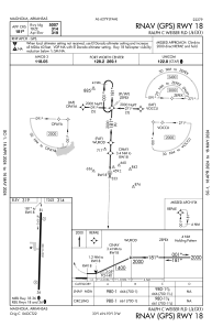
Communications frequencies: [VIEW]
Runways:
| RWY identifier | QFU | Length (ft) | Width (ft) | Surface | LDA (ft) |
| 18 | 182° | 5007 | 100 | ASPH | |
| 36 | 2° | 5007 | 100 | ASPH |
Airport contact information
Address: Magnolia United States