


KAEX - Alexandria Intl
Located in Alexandria, United States
ICAO - AEX, IATA - AEX
Data provided by AirmateGeneral information
Coordinates: N31°19'39" W92°32'55"
Elevation is 88 feet MSL.
Magnetic variation is 03° East View others Airports in Louisiana
Operational data
Special qualification required
Current time UTC:
Current local time:
Weather
METAR: KAEX 091853Z 00000KT 3SM HZ OVC043 29/24 A2977 RMK AO2 SLP083 T02940239
TAF: KAEX 091739Z 0918/1018 VRB05KT 2SM HZ BKN020 FM100000 18011KT P6SM VCTS BKN035CB OVC100 FM100800 36006KT P6SM BKN012 FM101600 02011G18KT 2SM HZ BKN030
Communications frequencies: [VIEW]
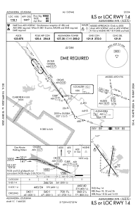
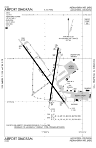
Runways:
| RWY identifier | QFU | Length (ft) | Width (ft) | Surface | LDA (ft) |
| 14 | 144° | 9352 | 150 | CONC | 9352 |
| 32 | 324° | 9352 | 150 | CONC | 9352 |
| 18 | 189° | 7001 | 150 | OTHER | 7001 |
| 36 | 9° | 7001 | 150 | OTHER | 7001 |
Airport contact information
Address: Alexandria United States