


KABE - Lehigh Valley Intl
Located in Allentown, United States
ICAO - ABE, IATA - ABE
Data provided by AirmateGeneral information
Coordinates: N40°39'9" W75°26'25"
Elevation is 393 feet MSL.
Magnetic variation is -12° East View others Airports in Pennsylvania
Operational data
Special qualification required
Current time UTC:
Current local time:
Weather
METAR: KABE 172151Z 19006KT 10SM FEW030 SCT040 OVC060 20/13 A2995 RMK AO2 SLP141 T02000133
TAF: KABE 171724Z 1718/1818 12004KT P6SM SCT020 OVC035 TEMPO 1719/1721 SCT020 BKN045 FM172100 15005KT P6SM BKN040 FM180700 VRB03KT 6SM BR VCSH OVC015 FM181400 VRB03KT 4SM -SHRA BR BKN008 OVC012
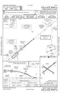
Communications frequencies: [VIEW]
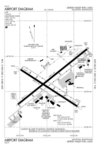
Runways:
| RWY identifier | QFU | Length (ft) | Width (ft) | Surface | LDA (ft) |
| 06 | 51° | 7599 | 150 | ASPH | 7599 |
| 24 | 231° | 7599 | 150 | ASPH | 7089 |
| 13 | 123° | 5800 | 150 | ASPH | 5800 |
| 31 | 303° | 5800 | 150 | ASPH | 5800 |
Airport contact information
Address: Allentown United States
