


KABE - Lehigh Valley Intl
Located in Allentown, United States
ICAO - ABE, IATA - ABE
Data provided by AirmateGeneral information
Coordinates: N40°39'9" W75°26'25"
Elevation is 393 feet MSL.
Magnetic variation is -12° East View others Airports in Pennsylvania
Operational data
Special qualification required
Current time UTC:
Current local time:
Weather
METAR: KABE 090651Z AUTO 03006KT 10SM CLR 15/07 A2969 RMK AO2 SLP049 T01500067 $
TAF: KABE 090531Z 0906/1006 31005KT P6SM SCT250 FM091600 VRB04KT P6SM OVC100 FM092000 13005KT 6SM -SHRA OVC040 FM100100 10007KT 6SM -SHRA BR OVC030 FM100300 10007KT 5SM -SHRA BR OVC015
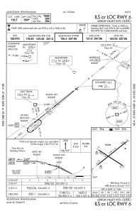
Communications frequencies: [VIEW]
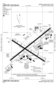
Runways:
| RWY identifier | QFU | Length (ft) | Width (ft) | Surface | LDA (ft) |
| 06 | 51° | 7599 | 150 | ASPH | 7599 |
| 24 | 231° | 7599 | 150 | ASPH | 7089 |
| 13 | 123° | 5800 | 150 | ASPH | 5800 |
| 31 | 303° | 5800 | 150 | ASPH | 5800 |
Airport contact information
Address: Allentown United States
