


K33 - Salem Meml
Located in Salem, United States
ICAO - K33, IATA -
Data provided by AirmateGeneral information
Coordinates: N37°36'55" W91°36'16"
Elevation is 1241 feet MSL.
Magnetic variation is 02° East View others Airports in Missouri
Operational data
Special qualification required
Current time UTC:
Current local time:
Weather at : KTBN - Waynesville-St Robert Rgnl Forney Fld ( 49 km )
METAR: KTBN 091255Z AUTO 27004KT 10SM CLR 16/11 A2977 RMK AO2 SLP077 T01560112
TAF: TAF KTBN 091254Z 0913/1019 28006KT 9999 SKC QNH2977INS BECMG 0916/0918 29010G25KT 9999 SKC QNH2982INS BECMG 1000/1002 31009KT 9999 SKC QNH2986INS BECMG 1007/1009 34006KT 9000 BR OVC013 QNH2994INS BECMG 1008/1010 34009KT 9000 BR BKN006 OVC013 QNH2995INS BECMG 1009/1011 35009KT 9999 RA OVC013 QNH2996INS BECMG 1014/1016 35006KT 9999 NSW OVC014 QNH3004INS BECMG 1015/1017 35009KT 9999 SCT014 OVC022 QNH3006INS BECMG 1017/1019 34006KT 9999 -RA SCT030 SCT045 QNH3006INS TX22/0920Z TN13/1012Z
Communications frequencies: [VIEW]
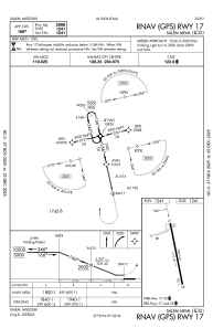
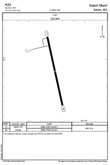
Runways:
| RWY identifier | QFU | Length (ft) | Width (ft) | Surface | LDA (ft) |
| 17 | 168° | 2998 | 60 | ASPH | |
| 35 | 348° | 2998 | 60 | ASPH |
Airport contact information
Address: Salem United States