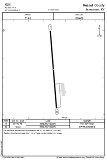


K24 - Russell County
Located in Jamestown, United States
ICAO - K24, IATA -
Data provided by AirmateGeneral information
Coordinates: N37°0'35" W85°6'10"
Elevation is 1010 feet MSL.
Magnetic variation is -04° East View others Airports in Kentucky
Operational data
Special qualification required
Current time UTC:
Current local time:
Weather at : KEKQ - Wayne County ( 28 km )
METAR: KEKQ 090130Z AUTO 07008KT 10SM -RA BKN009 BKN026 OVC070 18/ A2983 RMK AO2 LTG DSNT ALQDS TSE20 CIG 005V017 P0005
Communications frequencies: [VIEW]
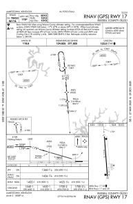
Runways:
| RWY identifier | QFU | Length (ft) | Width (ft) | Surface | LDA (ft) |
| 17 | 175° | 5010 | 78 | ASPH | |
| 35 | 355° | 5010 | 78 | ASPH |
Airport contact information
Address: Jamestown United States