


HLZT - Zelten - S22
Located in Ajdabiyah, Libyan Arab Jamahiriya
ICAO - , IATA -
Data provided by AirmateGeneral information
Coordinates: N28°57'19" E19°46'25"
Elevation is 493 feet MSL.
Magnetic variation is 4° East View others Airports in Al Wahat District
Operational data
Special qualification required
Current time UTC:
Current local time:
Weather at : - ( 0 km )
METAR: KUTS 181147Z AUTO 00000KT 1 1/2SM BR SCT002 OVC009 19/18 A2987 RMK AO2
Communications frequencies: [VIEW]
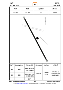
Runways:
| RWY identifier | QFU | Length (ft) | Width (ft) | Surface | LDA (ft) |
| 15 | 155° | 6024 | 99 | ASPH | |
| 33 | 335° | 6024 | 99 | ASPH |
Airport contact information
Address: Ajdabiyah Libyan Arab Jamahiriya