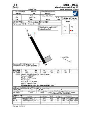
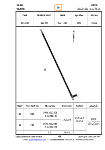


HLSH - Sahil
Located in Ajdabiya, Libyan Arab Jamahiriya
ICAO - , IATA -
Data provided by AirmateGeneral information
Coordinates: N29°32'30" E20°10'18"
Elevation is 105 feet MSL.
Magnetic variation is 4° East View others Airports in Al Wahat District
Operational data
Special qualification required
Current time UTC:
Current local time:
Weather at : - ( 0 km )
METAR: YBCG 180915Z AUTO 18016G26KT 9000 TSRA SCT017 SCT049 BKN063 15/14 Q1015
Communications frequencies: [VIEW]
Runways:
| RWY identifier | QFU | Length (ft) | Width (ft) | Surface | LDA (ft) |
| 16 | 157° | 4582 | 96 | ASPH | |
| 34 | 337° | 4582 | 96 | ASPH |
Airport contact information
Address: Ajdabiya Libyan Arab Jamahiriya