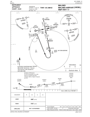


HKML - Malindi
Located in Malindi, Kenya
ICAO - HKML, IATA - MYD
Data provided by AirmateGeneral information
Coordinates: S3°13'23" E40°6'2"
Elevation is 88 feet MSL.
Magnetic variation is -1° East View others Airports in Coast Province
Operational data
Special qualification required
Current time UTC:
Current local time:
Weather
METAR: HKML 101600Z 21010KT 9999 SCT020 BKN080 26/23 Q1012
TAF: TAF HKML 101100Z 1012/1112 18010KT 9999 FEW021 BKN080 BECMG 1100/1103 00000KT SCT020 BECMG 1109/1112 21010KT FEW022 BKN080
Communications frequencies: [VIEW]
Runways:
| RWY identifier | QFU | Length (ft) | Width (ft) | Surface | LDA (ft) |
| 08 | 77° | 3432 | 48 | ASPH | 3346 |
| 26 | 257° | 3432 | 48 | ASPH | 3346 |
| 17 | 169° | 4601 | 91 | ASPH | 4601 |
| 35 | 349° | 4601 | 91 | ASPH | 4601 |
Airport contact information
Address: Malindi Kenya