


GCLB - Maspalomas - El Berriel
Located in El Berriel (Gran Canaria), Spain
ICAO - GCLB, IATA -
Data provided by AirmateGeneral information
Coordinates: N27°46'57" W15°30'25"
Elevation is 25 feet MSL.
View others Airports in Canary Islands
Operational data
Special qualification required
Current time UTC:
Current local time:
Weather at : GCLP - Gran Canaria ( 20 km )
METAR: GCLP 160900Z 01017KT 9999 SCT025 BKN040 20/13 Q1016 NOSIG
TAF: TAF GCLP 160800Z 1609/1709 01017KT 9999 BKN040 TX23/1614Z TN18/1706Z PROB30 TEMPO 1611/1618 01017G27KT
Communications frequencies: [VIEW]
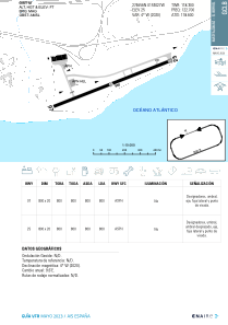
Runways:
| RWY identifier | QFU | Length (ft) | Width (ft) | Surface | LDA (ft) |
| 07 | 0° | 2625 | 66 | UNK | |
| 25 | 0° | 2625 | 66 | UNK |
Airport contact information
Address: El Berriel (Gran Canaria) Spain
