


GCAT - Aerodromo De Antigua-Fuerteventura (Las Palmas)
Located in , Spain
ICAO - , IATA -
Data provided by AirmateGeneral information
Coordinates: N28°23'28" W13°58'59"
Elevation is 561 feet MSL.
View others Airports in Canary Islands
Operational data
Special qualification required
Current time UTC:
Current local time:
Weather at : GCFV - Fuerteventura ( 14 km )
METAR: GCFV 161800Z 02016KT 9999 BKN040 22/12 Q1014
TAF: TAF GCFV 161400Z 1615/1715 02015KT 9999 SCT040 TX23/1714Z TN18/1706Z PROB30 TEMPO 1615/1620 02015G25KT
Communications frequencies: [VIEW]
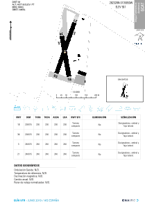
Runways:
| RWY identifier | QFU | Length (ft) | Width (ft) | Surface | LDA (ft) |
| 03 | 0° | 787 | 49 | UNK | |
| 18 | 0° | 656 | 49 | UNK | |
| 21 | 0° | 787 | 49 | UNK | |
| 36 | 0° | 656 | 49 | UNK |
Airport contact information
Address: Spain
