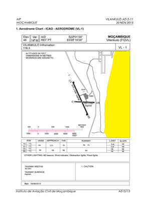


FQVL - Vilankulo / National
Located in Vilankulo, Mozambique
ICAO - FQVL, IATA - VNX
Data provided by AirmateGeneral information
Coordinates: S22°1'7" E35°18'47"
Elevation is 46 feet MSL.
View others Airports in Inhambane Province
Operational data
Special qualification required
Current time UTC:
Current local time:
Weather
METAR: FQVL 140900Z /////KT 9999 FEW020 28/19 Q1020
TAF: TAF FQVL 140400Z 1406/1506 20010KT 9999 BKN020 TX28/1413Z TN19/1502Z PROB40 TEMPO 1406/1412 5000 -RADZ SCT012 BKN018 BECMG 1412/1414 16014G26KT BECMG 1418/1420 18010KT
Communications frequencies: [VIEW]
Runways:
| RWY identifier | QFU | Length (ft) | Width (ft) | Surface | LDA (ft) |
| 10 | 89° | 2461 | 75 | ASP | |
| 28 | 269° | 2461 | 75 | ASP | |
| 17 | 156° | 4823 | 98 | ASP | |
| 35 | 336° | 4823 | 98 | ASP |
Airport contact information
Address: Vilankulo Mozambique