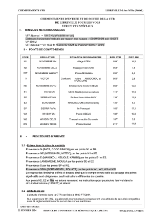
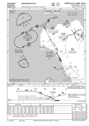
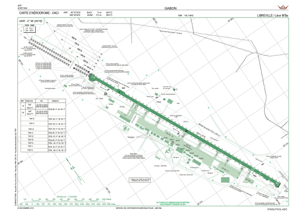


FOOL - Libreville/Leon M'ba
Located in Libreville, Gabon
ICAO - FOOL, IATA - LBV
Data provided by AirmateGeneral information
Coordinates: N0°27'30" E9°24'44"
Elevation is 38 feet MSL.
View others Airports in Estuaire Province
Operational data
Special qualification required
Current time UTC:
Current local time:
Weather
METAR: FOOL 210500Z 09005KT 8000 -TSRA FEW010 FEW018CB BKN026 26/26 Q1011 NOSIG
TAF: TAF FOOL 202300Z 2100/2206 27006KT 9999 TS SCT012 FEW020CB SCT033 BECMG 2000/2102 NSW SCT010 BKN030
Communications frequencies: [VIEW]
Runways:
| RWY identifier | QFU | Length (ft) | Width (ft) | Surface | LDA (ft) |
| 16 | 154° | 9843 | 148 | ASP | |
| 34 | 334° | 9843 | 148 | ASP |
Airport contact information
Address: Libreville Gabon