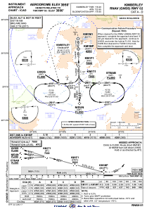
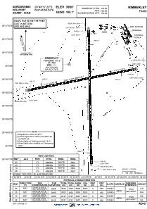


FAKM - Kimberley
Located in Kimberley, South Africa
ICAO - FAKM, IATA - KIM
Data provided by AirmateGeneral information
Coordinates: S28°48'10" E24°45'55"
Elevation is 3950 feet MSL.
Magnetic variation is -22° East View others Airports in Northern Cape
Operational data
Special qualification required
Current time UTC:
Current local time:
Weather
METAR: FAKM 100600Z 36010KT CAVOK 18/07 Q1019
TAF: TAF FAKM 100300Z 1004/1015 35010KT CAVOK TX29/1012Z TN16/1004Z
Communications frequencies: [VIEW]
Runways:
| RWY identifier | QFU | Length (ft) | Width (ft) | Surface | LDA (ft) |
| 02 | 360° | 9841 | 144 | ASPH | 9849 |
| 20 | 180° | 9841 | 144 | ASPH | 9849 |
| 10 | 80° | 7939 | 140 | ASPH | 7995 |
| 28 | 260° | 7939 | 140 | ASPH | 7995 |
Airport contact information
Address: Kimberley South Africa
